Finding Maps Beyond NYU Libraries
Some excellent sources for maps, both digital and print, include:
Geography & Map Division, Library of Congress
Map Collection, University of Texas Libraries
Maps
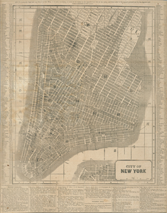
Maps are useful for understanding a place in a particular time, within a particular cultural context. They are imporant souces of rich information that are sometimes overlooked by researchers.
Image: [Map of the city of New York.] ([1850?]). New York Public Library. Stephen A. Schwarzman Building / The Lionel Pincus and Princess Firyal Map Division. Catalog Call Number: Map Div. 89-5055 [Filed flat]. Image ID: 434106
Recommended Reading for Using Maps
 Jenny Presnell's The Information Literate Historian (New York: Oxford University Press, 2007) provides an insightful overview of maps that covers the historical uses of maps, and includes tips for understanding the components of modern maps, reading and evaluating maps, finding maps to use in research, and more.
Use Presnell's book to learn about maps used for navigation and commercial use, as political tools, propaganda, territory markers, and how they are used in war.
Evaluating Maps
Evaluate maps as you would any other source.
Notice what kind of map you are reading. Does it describe the topography of an area, the political divisions, climate zones, population demographics, etc.?
Consider the author/creator of the map. Ask who made it and why. From what perspective is the map drawn?
What is at the center of the map?
Does the map contain extra text or illustrations? An illustrated border? Does it add to your understanding of the map?
Was the map part of a larger collection or volume?
What is missing from the map?
Sources: Mary Lynn Rampolla. A Pocket Guide to Writing in History, 6th ed. (New York: Bedford/St. Martin's, 2009) and Jenny L. Presnell. The Information-Literate Historian. New York: Oxford University Press, 2007.
